


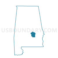
2H Harrison Elementary School Voting District, Montgomery County, Alabama
About
Outline

Summary
| Unique Area Identifier | 522698 |
| Name | 2H Harrison Elementary School Voting District |
| County | Montgomery County |
| State | Alabama |
| Area (square miles) | 2.96 |
| Land Area (square miles) | 2.78 |
| Water Area (square miles) | 0.18 |
| % of Land Area | 93.93 |
| % of Water Area | 6.07 |
| Latitude of the Internal Point | 32.31663790 |
| Longtitude of the Internal Point | -86.32208570 |
Maps


Graphs
Select a template below for downloading or customizing gragh for 2H Harrison Elementary School Voting District, Montgomery County, Alabama


Neighbors
Neighoring Voting District (by Name) Neighboring Voting District on the Map
- 2A St. Paul AME Church, Montgomery County, AL
- 2B Beulah Baptist Church Voting District, Montgomery County, AL
- 2C Carver High School Voting District, Montgomery County, AL
- 2F Fire Station No. 14 Voting District, Montgomery County, AL
- 2G Hayneville Road Community Center Voting District, Montgomery County, AL
- 2I Southlawn Elementary School Voting District, Montgomery County, AL
- 5A Seth Johnson Elementary School Voting District, Montgomery County, AL
- 5B Snowdoun Womens Club Voting District, Montgomery County, AL
Top 10 Neighboring County Subdivision (by Population) Neighboring County Subdivision on the Map
- Montgomery CCD, Montgomery County, AL (189,183)
- Pike Road CCD, Montgomery County, AL (19,164)
- Hope Hull CCD, Montgomery County, AL (8,627)
Top 10 Neighboring Place (by Population) Neighboring Place on the Map
Top 10 Neighboring Unified School District (by Population) Neighboring Unified School District on the Map
Top 10 Neighboring State Legislative District Lower Chamber (by Population) Neighboring State Legislative District Lower Chamber on the Map
- State House District 76, AL (44,894)
- State House District 77, AL (34,998)
- State House District 78, AL (30,880)
Top 10 Neighboring State Legislative District Upper Chamber (by Population) Neighboring State Legislative District Upper Chamber on the Map
Top 10 Neighboring 111th Congressional District (by Population) Neighboring 111th Congressional District on the Map
Top 10 Neighboring Census Tract (by Population) Neighboring Census Tract on the Map
- Census Tract 59.01, Montgomery County, AL (4,865)
- Census Tract 22.01, Montgomery County, AL (4,518)
- Census Tract 21, Montgomery County, AL (4,091)
- Census Tract 31, Montgomery County, AL (3,774)
- Census Tract 59.02, Montgomery County, AL (3,762)
- Census Tract 60, Montgomery County, AL (3,611)
- Census Tract 23, Montgomery County, AL (3,136)
- Census Tract 61, Montgomery County, AL (2,243)
- Census Tract 24, Montgomery County, AL (2,008)
- Census Tract 56.10, Montgomery County, AL (1,284)